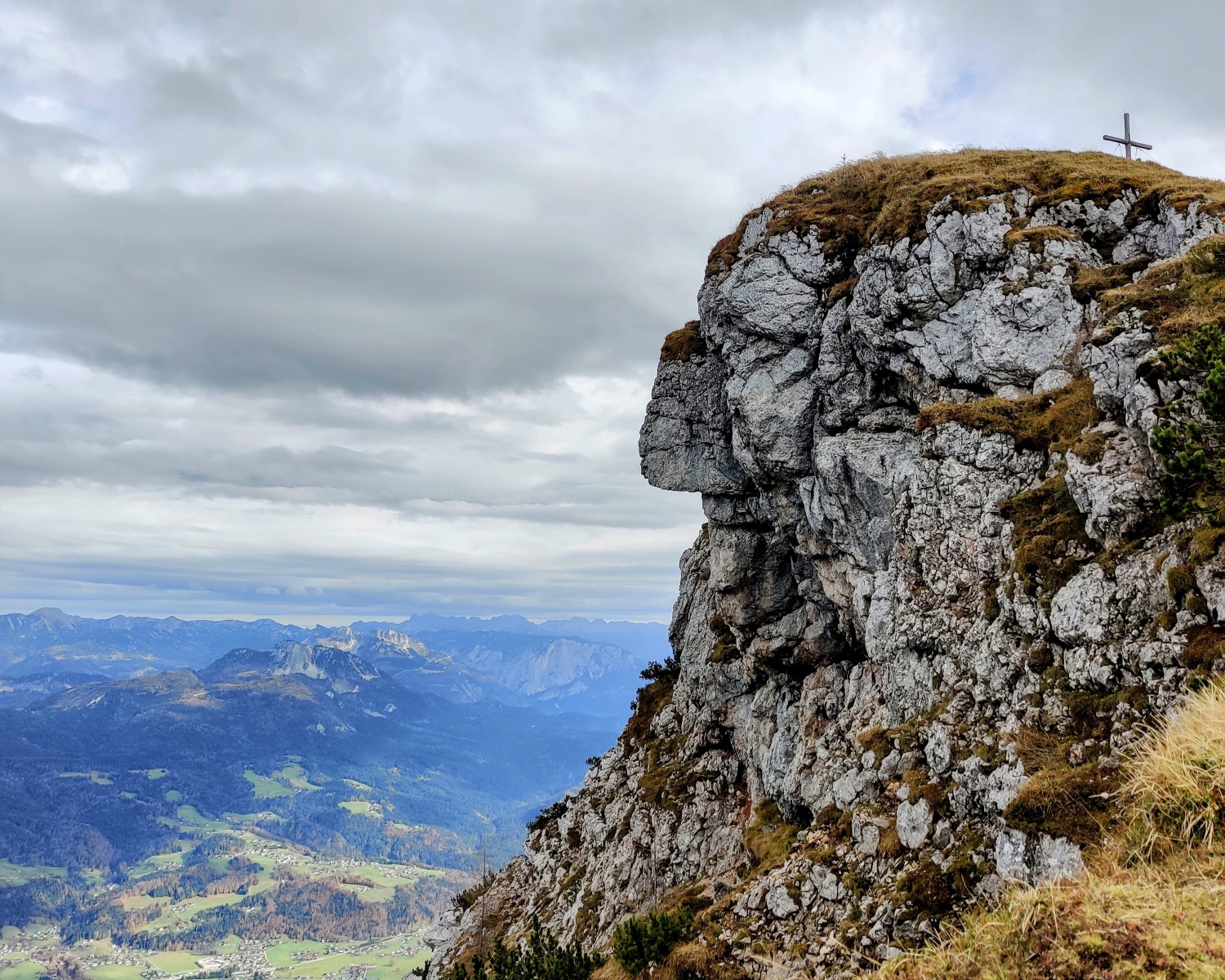

The Indian made of rock on the Hoher Kalmberg
The fastest route to this destination
The Indian made of rock on the Hoher Kalmberg
A crossing from Gosau to Bad Goisern, during which a rest at the Goiserer Hut should of course not be missed
The summit of the Hoher Kalmberg bears the nickname Indian Head for good reason. The rock formation below the summit cross strongly resembles the face of a Native American. The summit cross gives the chief his headdress. The Indian watches over Bad Goisern and from his head there is a wonderful view of the Gosaukamm and the Dachstein. Also interesting on the way is the Kalmoos Church, a rock cave where Protestants once held secret religious services.
moderate
6h 25min

15.23 km

A to B

Bad Goisern

Seasons


Directions
At the stop, turn left into Ramsaustraße and follow the signs to Iglmoosalm. After a short stretch through the settlement, narrow paths initially lead over a meadow and then steadily uphill northwards into the forest. At the forest road, turn right again onto the forest path and up to Igelmoosalm (1,206 m), where the peaks of the Gosaukamm are already visible. Behind the alm, take a path through the forest to the forest road, follow this to the right. Heading north, it goes steadily uphill over an old high path to Schartenalm. From here it is not far to the Goiserer Hut. But before the stopover, there is still the summit ascent on path no. 888 to the south. You pass the Kalmoos Church, a rock cave where Protestants once held secret religious services. The path continues through a dwarf pine ridge and some rock passages until you can recognize the profile of the Kalmberg Indian just below the summit. The summit cross (1,833 m) stands on his head. Descent back to the Goiserer Hut, then eastwards over partly steep path sections into the forest. You pass the Wallmann-Poidl rest with a small shelter and descend along the streambed to the material cable car. The path continues along the Schüttbach to the Trockentannalm. Now follow the forest road to the hiking car park and on the Bachgrabenstraße and via a small side path to the Traun. Over the bridge and down the river on the Traunreiterweg to the station.
By public transport
Arrival: Bus 150 to Bad Ischl, change to Bus 5 (stop) Gosau Ramsau B166 or: IC to (stop) Golling-Abtenau, change to Bus 460 (stop) Gosau Alte Gschüttstraße Siedlung
Return: (stop) Bad Goisern Rex to (stop) Bad Ischl, change to Bus 150
Timetable information and download: Online at www.salzburg-verkehr.at or on your smartphone via the free Salzburg Verkehr app for Android and iOS.
Route profile
All content has been researched by the editorial team to the best of their knowledge. However, the editorial team of Salzburger Verkehrsverbund GmbH cannot guarantee the completeness, accuracy, or timeliness of the information provided. We kindly ask you to verify the details when planning your trip, as opening hours, admission prices, or other information may change. Any liability claims against the editorial team or Salzburger Verkehrsverbund GmbH relating to material or non-material damages arising from the use of the information provided, or from the use of incorrect or incomplete information, are generally excluded.