
From the Riedingtal in Zederhaus to Stockham-Hüttschlag in Großarltal
The fastest route to this destination
From the Riedingtal in Zederhaus to Stockham-Hüttschlag in Großarltal
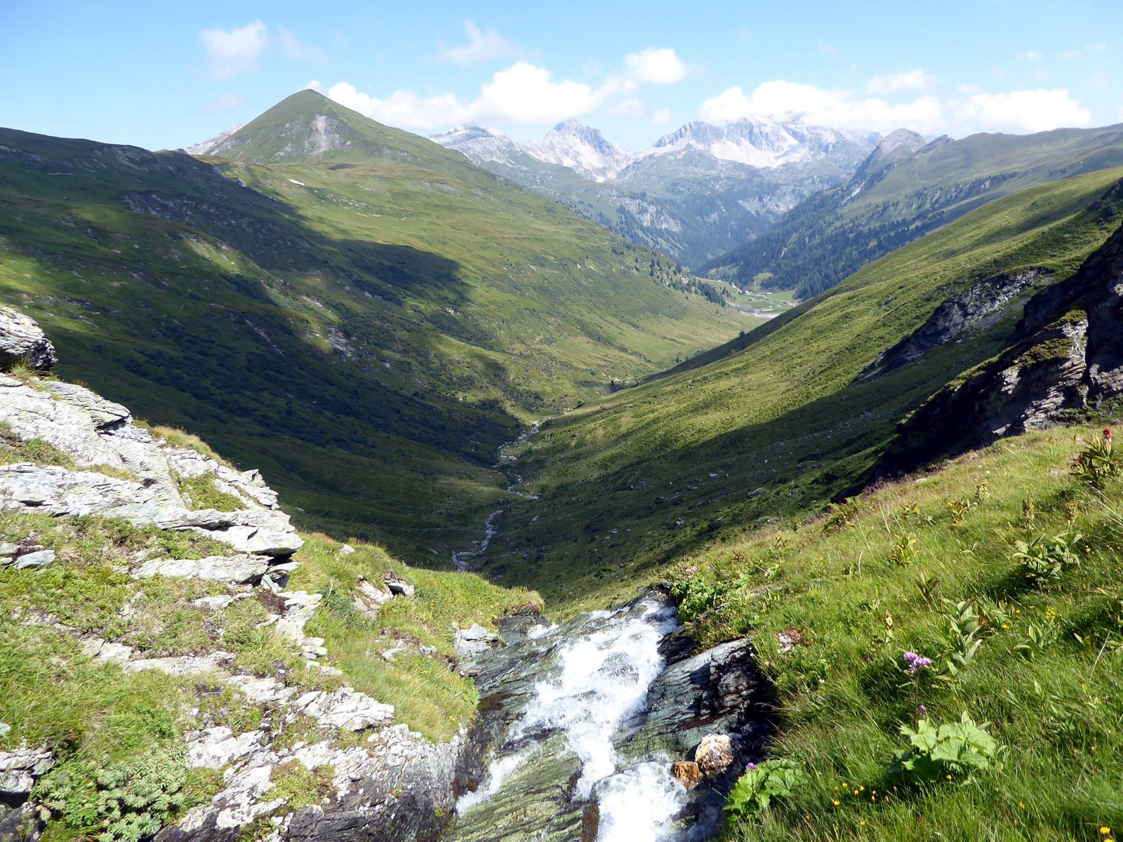
A QUIET DREAM TRAIL OVER THE WATERFALL PLAIN AND THE NEBELKARSCHARTE FROM LUNGAU TO PONGAU.
Thanks to the valley bus in the Riedingtal, the elevation difference to be overcome from the last stop Königalm (1,667 m) to the Nebelkarscharte (2,453 m) is kept within limits with 700 meters of ascent. The descent to Stockham (1,073 m) at the valley end of the Großarltal is somewhat more significant with just under 1,500 meters of elevation and should not be underestimated. In between spreads an incredibly varied landscape with almost paradisiacal dimensions. Romantic alpine meadows, then as a centerpiece a spectacular waterfall from which the Riedingbach develops, and for those who want (and have the stamina) as an extra to take along, the scenic Nebelkareck (2,535 m), inhabited by countless poisonous iron hats and bleating sheep. The only small flaw is a short cable-secured section before the Waterfall Plain, which requires surefootedness.
moderate
5h 15min

12.47 km

A to B

Zederhaus

Seasons


Directions
The starting point of the crossing is the last stop Königalm in the Riedingtal. Downhill at first it goes on wide paths past Zauner and Örgenhiasalm, afterwards the path narrows and from the spectacular waterfall stage on it also becomes briefly really steep. After 1.5 hours, arrived at the upper edge, the Waterfall Plain unfolds, a fairy-tale landscape shaped by small lakes and streams. Unfortunately, the signpost for Nebelkarscharte, Murtörl, or Stockham is missing at the fork, but the excellently marked route heading south is unmistakable and leads in an hour to the Nebelkarscharte. The Nebelkareck (2,535 m) is only a quarter of an hour or 100 meters of elevation away, but the main path crosses to the Murtörl (2,260 m). A memorial shrine commemorates the shepherd who froze on July 12 (!) 1954 and is also a reminder of the alpine dangers at any time of the year. The long descent leads mostly following the creek through the huge Kreekar to the two summer-operated Kreealmen (1,570 m) and from there, barring shortcuts, along the alpine access road down to the bus stop Hüttschlag valley end.
Information & contact
www.grossarltal.info/de/urlaub/grossarltal/huettschlag
Mag. Christian Heugl
5400 Hallein
christian.heugl@gmail.com
Image credit: Christian Heugl
By public transport
From Bischofshofen station (forecourt) take bus 270 to Zederhaus town center, bus 700 to Zederhaus Schliereralm, valley bus 772 to Königalm. Observe summer schedule, valley bus runs until the first week of September.
Return from Hüttschlag valley end (Stockham) with bus 540 to St. Johann station (forecourt) and by train to Salzburg main station.
Frequency: from the Salzburg city area, only a morning connection to the destination Zederhaus Königalm is useful. Return from Hüttschlag valley end with bus 540 frequent, last bus on weekdays at 6 p.m., on weekends (holidays) at 5 p.m. Good planning is necessary! https://salzburg-verkehr.at/downloads/regionalbus-540-st-johann-grossarl-huettschlag-stockham/
Timetable information and download: Online at www.salzburg-verkehr.at or on your smartphone via the free Salzburg Verkehr app for Android and iOS.
Safety information
Surefootedness required for the ascent at the Waterfall Plain.Route profile
All content has been researched by the editorial team to the best of their knowledge. However, the editorial team of Salzburger Verkehrsverbund GmbH cannot guarantee the completeness, accuracy, or timeliness of the information provided. We kindly ask you to verify the details when planning your trip, as opening hours, admission prices, or other information may change. Any liability claims against the editorial team or Salzburger Verkehrsverbund GmbH relating to material or non-material damages arising from the use of the information provided, or from the use of incorrect or incomplete information, are generally excluded.