


Weißsee glacier world
The fastest route to this destination
Weißsee glacier world
An easy yet impressive circular hike at about 2,300 m altitude around the Rudolfshütte mountain station. The well-developed path offers magnificent views of glaciers, crystal-clear mountain lakes, and the surrounding high mountain world. Ideal for families, leisurely hikers, and as an acclimatization route. Walking time approx. 1 – 1.5 hours, minimal elevation changes, dining option at the Rudolfshütte.
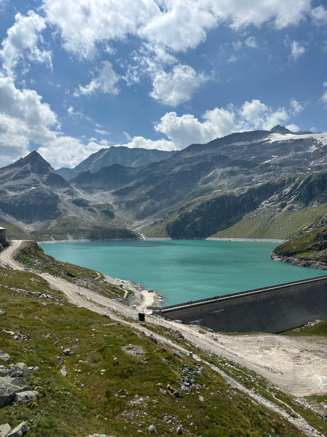
The easy panoramic loop in the Weißsee glacier world is a perfect introduction to the high alpine landscape of the Hohe Tauern – without great effort but with spectacular views. Starting from the Rudolfshütte mountain station at about 2,315 m altitude, the well-marked circular route leads through an impressive glacier landscape, past small mountain lakes, boulders, and alpine meadows.
The path is wide, easy to walk, and nearly flat, making it perfect for leisurely hikers, families with children, or guests with little mountain experience. It also serves as a short acclimatization route or as a complement to a day trip by cable car.
Especially rewarding are the views of the Weißsee, the Sonnblickkees glacier, and the surrounding three-thousand-meter peaks. Along the way, numerous photo spots and natural benches invite you to linger. The pure walking time depends on pace and ranges between 60 and 90 minutes. Those who wish can end the route with a visit to the sun terrace or a meal at Rudolfshütte.
A circular route that, despite its short length, evokes alpine high-altitude feelings – and all without great effort.
easy
2h 25min

4.33 km

Family-friendly

Stroller-friendly

Round trip

Uttendorf/Weißsee

Seasons


Directions
The Rudolfshütte panorama path begins directly at Rudolfshütte and leads to the Schafbühel viewpoint, from which you enjoy a spectacular view of the Weißsee glacier. The path is a circular route offering a pleasant, easy hike. Along the path, information boards explain the geological features and the region's flora. The return path follows a different section of the route, making for a varied round trip. Even without longer breaks or photo stops, the entire round takes about 30 minutes. The area also offers many other hiking trails suitable for various difficulty levels and preferences.
By public transport
By train & bus to the Enzingerboden Weißsee cable car valley station bus stop🚏
Coming from Salzburg, you reach the Enzingerboden Weißsee cable car valley station bus stop as follows: first take the S3 to Zell am See station, then change to bus 670 at Zell am See station until the Uttendorf town center stop. From here, take bus 672 to the Enzingerboden Weißsee cable car valley station bus stop.
Timetable information and download:
Online at www.salzburg-verkehr.at or on your smartphone via the free Salzburg Verkehr app for Android and iOS.
Route profile
All content has been researched by the editorial team to the best of their knowledge. However, the editorial team of Salzburger Verkehrsverbund GmbH cannot guarantee the completeness, accuracy, or timeliness of the information provided. We kindly ask you to verify the details when planning your trip, as opening hours, admission prices, or other information may change. Any liability claims against the editorial team or Salzburger Verkehrsverbund GmbH relating to material or non-material damages arising from the use of the information provided, or from the use of incorrect or incomplete information, are generally excluded.