
From Strobl at Wolfgangsee to the Bleckwand
The fastest route to this destination
From Strobl at Wolfgangsee to the Bleckwand
The Wolfgangsee and its surroundings are actually much-visited summer resort locations. But winter also offers excellent destinations for friends of extraordinary ski tours.
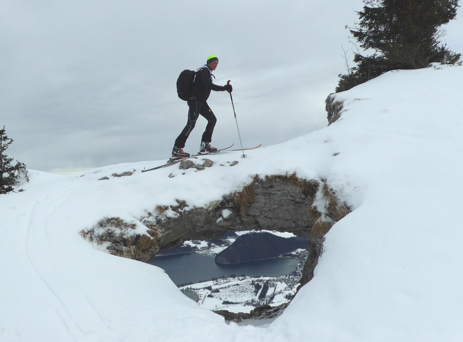
Regarding the ratio of the descent over open slopes to the total altitude meters, there may be more rewarding ski tour destinations in the Osterhorn group. But there are times and reasons when the detour to the Bleckwand (1541 m) with the long section on the toll road closed in winter is exactly right. One advantage is the hardly existent avalanche danger; another is the easy accessibility. The half-hourly bus 150 between Salzburg and Bad Ischl stops directly at the starting point of the environmentally friendly tour. So just strap on your skis at the Strobl-Landauer bus station and the ski tour on the Bleckwand begins. Naturally, as a crowning conclusion, the spectacular rock window with a view of the Strobler Bay must not be missed. A must-stop for all photographers and Instagrammers.
Direct access and details at: salzburg-erfahren.at
moderate
3h 5min

12.02 km

Round trip

Strobl

Seasons


Directions
The ascent begins at the Landauer stop and first leads westward across the meadow, then follows the crossing goods road through the forest to Hof Vitz. There, the toll barrier is located, and from then on the closed road is no longer cleared. The easiest ascent follows the Niedergadenstraße (path 874) for one hour to the Alpengasthof Schwarzeneckalm and then turns left onto a forest road leading to the Bleckwandhütte (1329 m). You can also reach it via the steeper and shorter summer path (path 876), which branches off earlier. From the scenic Bleckwandhütte, the last part of the route follows the lightly wooded ridge in a southeast direction. Shortly before the summit cross, the rock arch opens up, revealing the view of the Wolfgangsee. Most tourers end the ascent at the cross (1516 m), which was erected slightly before the highest point. A beautiful descent variant follows the Bleckwand ridge another 200 meters southeast and then turns right into the forest. Soon a nice southwest-facing slope opens up that leads down to the Wetzlerhütte (1228 m) at the end of the toll road. The further descent follows the road or the slopes beside it.
Information & contact
Mag. Christian Heugl
5400 Hallein
cheugl@a1.net
Image credit: Christian Heugl
Info Bleckwandhütte: Due to a comprehensive renovation, the hut is expected to remain closed until 2026. Current information on the renovation progress can be regularly found on the website www.bleckwandhuette.naturfreunde.at.
By public transport
Take bus 150 to the stop "Gschwendt Strobl Landauer."
Timetable information and download: Online at www.salzburg-verkehr.at or on your smartphone via the free Salzburg Verkehr app for Android and iOS.
Direct access and details at: salzburg-erfahren.at
Safety information
Always carry the complete ski touring safety equipment in your rucksack: avalanche transceiver, shovel, probe, smartphone.Route profile
All content has been researched by the editorial team to the best of their knowledge. However, the editorial team of Salzburger Verkehrsverbund GmbH cannot guarantee the completeness, accuracy, or timeliness of the information provided. We kindly ask you to verify the details when planning your trip, as opening hours, admission prices, or other information may change. Any liability claims against the editorial team or Salzburger Verkehrsverbund GmbH relating to material or non-material damages arising from the use of the information provided, or from the use of incorrect or incomplete information, are generally excluded.